UAVs/drones capture as-built conditions from every angle
UAVs and drones are transforming construction documentation. How do they fit into a modern project workflow?
Managing and reviewing reality capture data is a significant challenge. As-built records must be kept updated with accurate visuals to properly assess site conditions. Teams now have access to UAVs/drones that provide observations beyond human capability and enable measurements from cloud-based platforms shareable from any internet-connected device.
The Basics of Construction Drones
Does UAV/drone-powered documentation come with any challenges?
What Is UAV/Drone Documentation In Construction?
UAVs/drones are remotely piloted aircraft systems (RPAS) that carry sensors to capture construction site data from the air.
Equipped with high-definition cameras, LiDAR, thermal, multispectral, and gas detection sensors, they capture precise 3D spatial data for mapping, modeling, and inspections.
Uses for captured data:
– 3D mapping
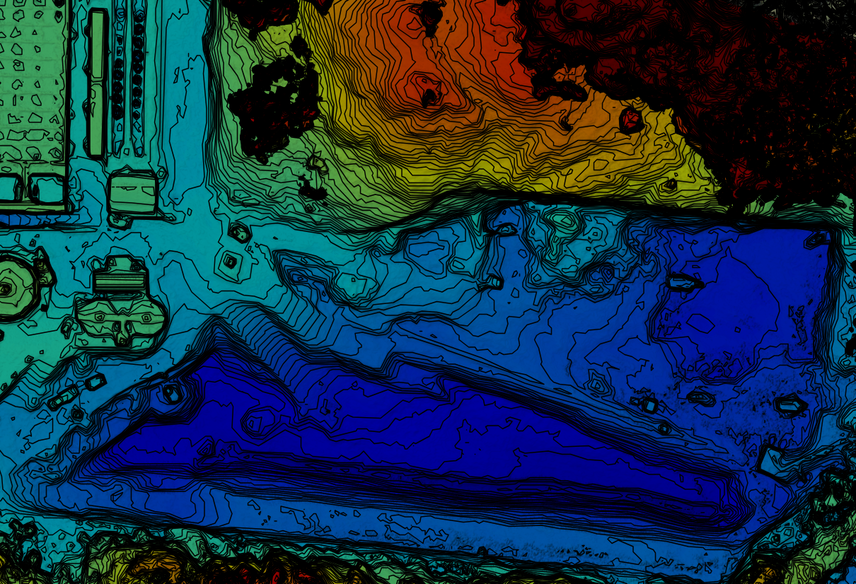
– Topographic modeling
– Accurate terrain measurements
– QA/QC and inspection
– Promotional marketing efforts
How Does UAV/Drone Documentation Work?
UAVs and drones equipped with high-definition cameras, LiDAR, thermal, and multispectral sensors fly over construction sites capturing data from above—delivering observations beyond human capability.
Depending on the sensor payload, a single flight can generate thousands of data points used to build 3D models, topographic maps, and measurable project footprints.
What is the best drone setup for construction?
There is no single best drone setup for construction sites; the best option will depend on your organization unique needs and priorities.
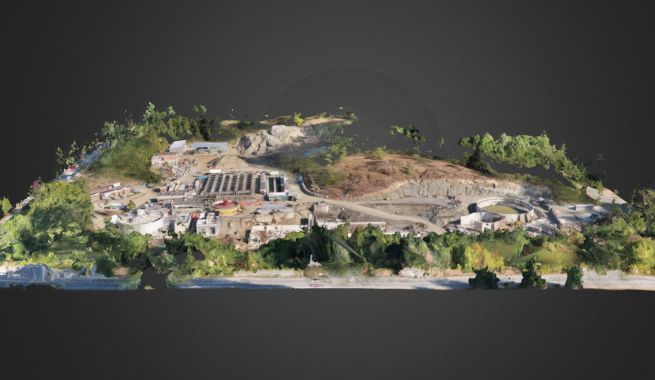
Construction UAVs/drones deliver actionable intelligence at every stage. Multivista drones capture multiple perspectives at varying elevations, flying 10x closer than standard aerial photography—capturing straight-down, oblique angle, flyover, and panoramic views for comprehensive documentation.
DRONE CONSIDERATIONS
There is no single best drone for construction sites; the best option depends on your priorities.
Sensor payload
High-definition cameras, LiDAR, thermal, or multispectral sensors each serve different documentation needs.
Flight endurance
Larger sites require longer battery life or multiple batteries to complete a full documentation pass.
Data processing
Consider whether you need real-time data or can process post-flight. Cloud-based platforms enable sharing from any device.
Regulatory compliance
All drone operations must comply with local aviation regulations, registration requirements, and airspace restrictions.
UAV/Drone Mapping: Unlocking a New Level of On-Site Visibility
When it comes to UAV/drone mapping on a construction site, teams can choose between managing flights in-house or partnering with a professional documentation provider.
Ultimately, the right choice depends on your organization needs, budget, and the complexity of your projects.
In-house Drone Operations
To keep everything in-house, you will need to invest in the necessary equipment, obtain certifications, and provide sufficient training for your team. You maintain full control over scheduling and data ownership, but take on all operational and compliance responsibilities.
Third-party Drone Provider
Outsourcing to an experienced drone documentation provider removes the operational burden from your team. A professional provider brings certified pilots, professional-grade equipment, and established workflows to deliver high-quality aerial data in compliance with local regulations.
Key Benefits
Improved safety and reduced liability
Drones check safety structures, monitor conditions, and reach dangerous areas without putting personnel at risk, reducing liability across the project lifecycle.
Streamlined progress documentation
Drones capture extensive information quickly, creating efficient, up-to-date visuals that stakeholders can access from any internet-connected device.
More advanced visuals
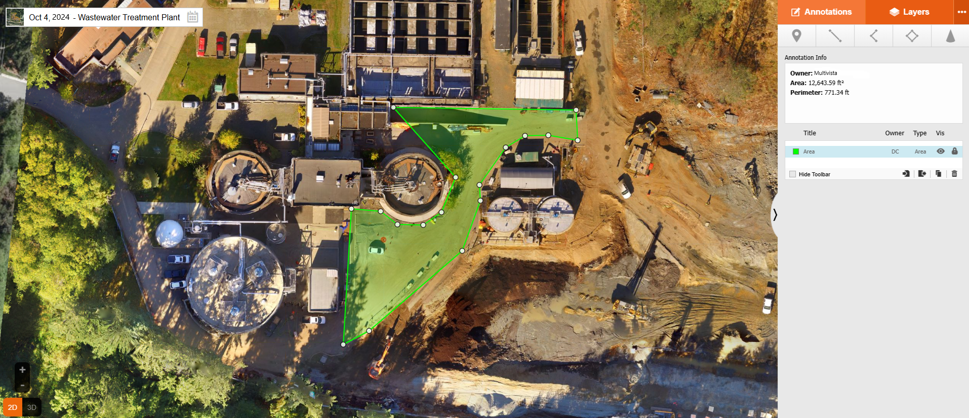
Photogrammetry cameras create 3D models with linear, area, and volume measurements for fence lines, hardscapes, and slabs—delivering data far beyond what manual surveys provide.
Coverage for large areas
Flying over entire sites requires significantly less time and labor than manual surveys, delivering comprehensive documentation of even the largest construction projects.
Enhanced site security and asset tracking
Bird-eye views identify security risks and help teams monitor equipment, tools, and materials movement and location across the entire site.
Are There Challenges Associated With UAVs/Drones?
While using UAVs/drones for construction documentation comes with numerous benefits, there are also a few common challenges to plan for.
Data Management
Vast amounts of aerial data require effective management. Avoid silos by ensuring cloud-based accessibility so all stakeholders can access up-to-date information.
Legal and Regulatory Constraints
Numerous regulations govern piloting, registration, flight restrictions, and data privacy – varying by location. Thorough research or vendor collaboration prevents noncompliance.
Weather-Related Challenges
Rain, high winds, and adverse weather conditions make flying difficult or impossible. Manual documentation becomes necessary in these cases.
Limited Access in Tight Spaces
Physical size constraints prevent drones from navigating through narrow corridors or tunnels. Alternative methods like 360-degree photography help fill these gaps.
Need for Specialized Training
Drone operations require technical flight training plus specialized data interpretation knowledge. Working with experienced providers reduces in-house training needs.
How different
stakeholders use it
Architects & Engineers
High-definition UAVs greatly accelerate site and land mapping. Aerial data creates comprehensive, high-resolution topographic maps showing elevation changes, natural features, and man-made structures—assisting architects and engineers with planning, design coordination, and risk assessment.
General Contractors & Project Managers
General contractors and project managers juggle troubleshooting, RFIs, schedules, and budgets especially on complex projects.
UAVs/drones capture varied angles with high precision and comprehensive coverage. Set to document identical angles over time, they show progress updates nearly in real-time, guiding materials tracking, equipment logistics, and meeting updates.
Owners & Developers
Construction UAVs/drones offer significant time, cost, and resource savings for owners and developers. Bird-eye views assist with logistics coordination, materials storage, and workflow optimization. Teams identify safety hazards, equipment path bottlenecks, and optimize workstations.
What is the future of UAVs/drones in construction?
As with many other construction technologies, the future of UAV/drone documentation is intertwined with artificial intelligence (AI).
As AI technology continues to advance, drones will become smarter—capable of autonomous flight, real-time anomaly detection, and automatic progress comparison against BIM models. The integration of drones with cloud platforms and AI-powered analytics will make aerial construction documentation faster, more accurate, and more actionable than ever before.
Additional technologies like radio frequency identification (RFID) will enable material identification from the air without manual effort, further streamlining construction workflows.
Multivista UAV & Drone services
As the global leader in construction documentation, Multivista will give you the aerial insights you need to better manage your projects.
With our UAV & Drone services, project teams can capture comprehensive aerial data, create 3D models, track progress from above, and access everything from any internet-connected device. Our certified drone pilots work with you to build a documentation schedule that fits your project timeline.
Here is how it works:
Your local Multivista team will work with you to create a schedule of aerial documentation flights at a cadence that works for you.
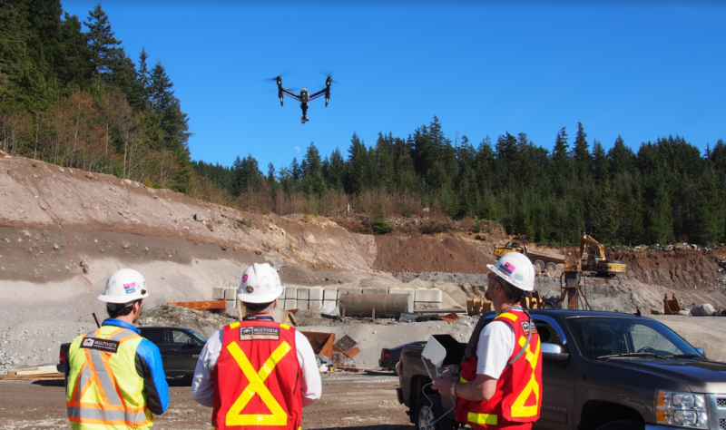
Multivista certified drone pilots use professional-grade UAVs equipped with high-definition cameras and LiDAR sensors.
All captured data is processed into 3D models, topographic maps, and measurable project footprints.
Your team can access, share, and analyze aerial data from any internet-connected device through our secure cloud-based platform.
Capturing multiple perspectives
Construction UAV/drone technologies deliver the actionable project intelligence you need at every step. Multivista construction UAVs/drones capture multiple perspectives at varying elevations of your project, so no detail is missed, flying 10x closer than standard aerial photography.
Let us capture your project straight down, at oblique angles, through project flyovers, or with sweeping panoramas so that all major details are documented properly and accurately.
Use UAV/Drone-captured video for progress and inspections
The most obvious use case for UAV video is for marketing purposes. However, UAV video is also regularly used for broad overviews of progress and for inspections.
Site perimeters can be flown much quicker and safer than doing a full walkaround and can capture a lot more detail over what can be seen from the ground. The resulting product can then be viewed by multiple people for more clarity of the condition and progress or provide value for multiple teams with different checklists in mind.
No matter the requirement, including UAV/Drone reality capture data as part of your planning, monitoring and construction processes will benefit you and your teams greatly.
Enhanced site management
Having a birds-eye view of the site can help immensely with logistics coordination, materials storing and overall site workflow.
Identify where potential safety hazards are, bottlenecks for vehicle and heavy equipment paths, and optimize onsite workstations.
Improve collaboration and decision making
Adding UAV/Drone reality capture data as part of weekly meetings, sub-trades coordination efforts and plan adjustments can help provide planning teams with even more information of current conditions and progress.
UAV/Drone reality capture data can help designers understand where key components of the project will be placed, and how they interact with the surrounding space or even provide opportunities for optimizations to the structure based on real-world conditions.
Success Case
British Columbia Institute of Technology (BCIT)
The British Columbia Institute of Technology (BCIT) is set to grow and modernize its six campuses in Metro Vancouver. For this plan, BCIT required comprehensive visual documentation of their facilities, covering 56 buildings and 3,000,000 square feet — one of British Columbia largest documentation projects.
Multivista accepted the challenge, utilizing a combination of 360 cameras, Leica RTC360 laser scanners, and Phantom 4 RTK UAVs to capture terabytes of 3D point cloud data.
56 buildings and 3,000,000 square feet documented over 6 campuses
Captured 40,000 images
1,500,000 images used for 3D models
Dozens of hours of UAV flight time, all viewable online on our secure, cloud-based platform